lone valley and relay are clear and (mostly) good riding
little graveyard has some blowdown
tyax pass trail is beautiful but you better enjoy side-hill bike walking
little paradise is a mixed bag of awesomeness mixed with swamp and salal shin-bashing
most ridges are completely clear of snow now
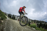
South Chilcotin 2012 (aka Spruce Lake)
lone valley and relay are clear and (mostly) good riding
little graveyard has some blowdown
tyax pass trail is beautiful but you better enjoy side-hill bike walking
little paradise is a mixed bag of awesomeness mixed with swamp and salal shin-bashing
most ridges are completely clear of snow now
Thanks for the update.
anyone recommend their favourite way out of spruce lake. Lick, Cinnabar, B[HTML_REMOVED]F or gun creek?
Bottom of Lick got logged, not sure how good it is anymore, used to be rad if you knew where to go
Cinnabar lands you well above tyax, but a good short lap if you park at trail exit
Gun creek is nice until you get below jewel bridge, rolling monotonous sand below
the clear cut on lick is passable.
Just a speculative fiction. No cause for alarm.
Everything is "passable". Is it still fun?!
Wifey did the lick creek descent (that sounds inappropriate).
Ride is still great and the cut-block only affected a very small part of the trail. No major loss.
only one way to find out
Just a speculative fiction. No cause for alarm.
Wifey did the lick creek descent (that sounds inappropriate).
Ride is still great and the cut-block only affected a very small part of the trail. No major loss.
did she lick lower? ;) how about lick even lower? ha
Just a speculative fiction. No cause for alarm.
this weekend did not suck up there….
ridge-o-rama friday


lorna saturday


lick sunday, mega lake time monday! I wasn't paying attention close enough in the new clearcut at the bottom of lick, and totally missed out on lower lick…it's pretty messy in there, even if passable.
Lower lick is still there.
Look for a cairn. Short walk through the cut-block. The cut block section is rideable but the sticklets are inspired and will try to hitch a ride in your derailler or spokes.
Flip those photos are stunning!
Lower lick is still there.
Look for a cairn. Short walk through the cut-block. The cut block section is rideable but the sticklets are inspired and will try to hitch a ride in your derailler or spokes.Flip those photos are stunning!
yeah I was looking for it, but must've gotten carried away with speed on the road….oh well! so hard to take bad pics in the sun up there, those are all iphone photos too!
Hey Mrs G, can you let the forum know which way you did the ride and riding time when done? I would be interested in your findings as Im doing the same and, Ive heard, a group taking nearly 12 hrs to do the loop (though they did run into glutinous mud and snow)
I wasn't ignoring ya! We just didn't head up until this past weekend.
We decided to do Deer Pass clock-wise as a loop from Spruce Lake. Our rationale - the south end looked steep and short, we thought we may have a better descent on the north side, plus we wanted to do the Tyaughton creek crossings at the end so we'd have dry feet for most of the day.
Friday evening we biked into Spruce Lake from Jewel Bridge. We took ultra-lite camping gear and enough food for 2 nights. Riding time was a relaxed 2hr 10min - total time was 2hr45min to the south campground.
The morning views were pretty spectacular.

Saturday we did Deer Pass. It took us 11 hours in total (but our GPS and bike computers clocked us around 6hr 40min moving time… ooops). We were hoping for 10hrs but ran into a few 'issues'. I'm (usually) competent, but not a super fast rider, so I'll give you our times on the different sections.
The first stretch from Spruce past Hummingbird and Trigger to the Deer Pass turn off is pretty easy going. We lost a bit of time when I had a brain-fart clipless moment and fell off the trail sliding down the bank next to Hummingbird - the only reason I didn't end up headfirst in the lake was because I crashed into a tree instead….oh well, bruises [HTML_REMOVED][HTML_REMOVED] drowning.
There was no marker at the south end of Deer Pass on Gun Cr trail so make sure to keep your eyes peeled for the trail. Took us [HTML_REMOVED]2hrs riding time, ~2hr30 total to ride from from Spruce Lake to the Deer turn off (including the incident above, and a stop for lunch and to refill water).
Deer Pass - OK, the first 1.5 - 2km of the hike-a-bike were STEEP! Really steep. We knew this from the map but I was still a bit surprised. I was questioning whether I'd even be able to ride down all of it (if we came from the opposite direction) - very steep, dry and loose.
After about 1.5 -2 hrs of hiking we broke out of the trees and it was a much more pleasant push / ride to the pass. Alpine flowers were in full bloom and the scenery was incredible.


We reached the summit in ~5.5 hours from Spruce.

But then I really struggled with the first 1km or so of the descent to the north. It was a pretty exposed side-hill. Took a looong time for me to walk down. I'm not proud of that part of our ride.
Then life got good, really good, after that first km. It was a pretty cruisy 5km descent back to the valley. Ran into 2 other groups coming the other way from Lorna - Hi FlipFantasia - nice to meet you on Saturday! Great pics!
Back on Tyaughton crk trail it's about 20-25? km back to Spruce Lake. We've done that stretch before and I quite enjoy it. Worth mentioning the creek was running pretty high and strong. I'm about 5'10" and it was above my knees in places. There are 4 crossings all within a 1km stretch. The first and third crossings were easy. The second crossing had a really strong current and I learned a new downside of 29" wheels - need to hold the bike much higher so the wheels don't get caught!! I actually couldn't get across on my own with my bike - needed to cash in a 'hubby help' card. Crossing #4 was also a bitch - hubby and I both got wet when he came to rescue me.
A downside of the clock-wise loop is you then have to climb up WD at the end of your day when you're tired. Personally I don't mind it that much as it's a mindless 15-20 min push followed by a cruisy descent to Spruce Lake.
We stayed at Spruce and rode out Gun Meadow the next morning. We following these paw prints for about 5km.

Now with Deer Pass checked off, I guess I need to add something else to my bucket list….
"I'm not an ambi-turner. I can't turn left."
nice to meet you too, Mrs. G, sounds like quite the adventure! that first/end part of Deer Pass is indeed steep, loose, and gnar…and ridiculously fun if you're willing to go with the flow…I certainly wouldn't opt to go up that way!
As for weird stuff out there, we were having a break on the pass after the hike and two trail runners rocked up, 3pm, on their way to Relay….holy shit, no thanks!
ridge-o-rama…was way gnarlier than I expected, but really fun. best like your hike a bikes though!
Forum jump:


