New posts

Burnaby Mountain 2015

May 27, 2015, 10:09 a.m.
Posts: 1150
Joined: Oct. 31, 2006

Speaking of climbing… oh wait, I wasn't… anyway…

with all the recent work done on UpperCut by BMBA and some recent follow-up by CoB (I believe), and the work done on GJ this winter by UniverCity, Jay Hoots, and some trail fairies, this is a pretty good alternative climbing route up the mountain.

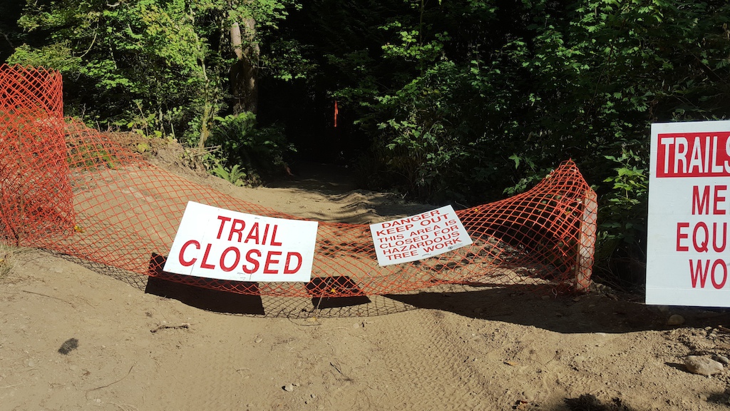
I recommend doing this NOT during peak hours, as things have bushed in pretty good with spring foliage, so sight-lines are pretty bad and their are a lot of skidding pinners coming down GJ that don't necessarily follow the ruler about stopping for uphill traffic.

But, in the morning, riding Function Junction, up UpperCut, up Lower and Upper GJ is a really good climb. For me, with a 30t front and 40t rear, it's about 85-90% rideable. Would only take a few tweaks to make it consistently 90%.

Another option, climbing Mel's from TransCanada to Upper GJ and then climbing Upper GJ is nearly 100% rideable now, with the exception of the first two switchbacks at the bottom of Mel's. They could be rideable with some trail fairy love. The other steep pitches were all filled in and buffed out by a trail fairy a couple months ago and are holding up well, making this a very pleasant climbing route with less DH traffic at Peak hours. Upper GJ has better site-lines than Lower GJ for climbing as well if doing it during higher traffic times.

Burnaby has also buffed up Pandora's as a climbing trail only. So this is a great link-up now and a reason to actually ride Hang Your Hat, Mountain Air, and Velodrome Trail.

May 27, 2015, 4:32 p.m.
Posts: 32
Joined: June 10, 2013

I use Mel's mainly for climbing to GJ or Nicole's etc. (when last year I would usually suffer up Cardiac thinking it was helping me become a better climber). Mel's is definitely a good technical climb that's challenging (especially now that Pandora is essentially paved).

The other day, I stared at that first hard right step up root on Mel's (from TCT) for about 10 minutes and made a few attempts to get up it (almost making it on the last few). I think it's possible, but for that I would take the line around the tree first which isn't really the proper route.

Anyhow… I like the Mel's climbing challenges. I think it's doable North to South as-is… but would take some skill, cardio and power to do it. :grinno: :agree:

I don't know that I'll be climbing Uppercut and GJ anytime soon (especially in peak hours as you say)… but I suppose it's an option. I'll push up lower GJ sometimes to ride down Uppercut though. I run/hike up those trails from time to time where looping trails together is so much easier.

May 29, 2015, 10 a.m.
Posts: 1150
Joined: Oct. 31, 2006

Looks like BMBA and the City are doing another trail day tomorrow. Or so says the FB: https://www.facebook.com/pages/Burnaby-Mountain-Biking-Association/166074226749735?fref=ts

The City has finished off UpperCut (or it seems so to me), so it would be great if the trail day focusses on Lower Snake. It badly needs some love. Getting to be some pretty big tired holes here and there.

May 29, 2015, 10:17 a.m.
Posts: 3154
Joined: Nov. 23, 2002

lower snake is a great climb, but fixing a few things would be nice.

We don't know what our limits are, so to start something with the idea of being limited actually ends up limiting us.
Ellen Langer

May 30, 2015, 2:08 p.m.
Posts: 3834
Joined: May 23, 2006

Looks like BMBA and the City are doing another trail day tomorrow. Or so says the FB: https://www.facebook.com/pages/Burnaby-Mountain-Biking-Association/166074226749735?fref=ts

The City has finished off UpperCut (or it seems so to me), so it would be great if the trail day focusses on Lower Snake. It badly needs some love. Getting to be some pretty big tired holes here and there.

I think they're planning on finishing up on the bottom half of UC for today.
Last I rode LS the only thing that caught my attention was the depression at the bottom of that steep paved section that should be filled in. Was thinking a large flat rock…..

Freedom of contract. We sell them guns that kill them; they sell us drugs that kill us.

May 30, 2015, 11:15 p.m.
Posts: 0
Joined: Oct. 14, 2008

Looks like BMBA and the City are doing another trail day tomorrow. Or so says the FB: https://www.facebook.com/pages/Burnaby-Mountain-Biking-Association/166074226749735?fref=ts

The City has finished off UpperCut (or it seems so to me), so it would be great if the trail day focusses on Lower Snake. It badly needs some love. Getting to be some pretty big tired holes here and there.

Thanks for the plug! but that was last Saturday - the 23rd. Unfortunately we only had 3 people come out (plus 2 bikers that stopped to help for a few hours) so we didn't get as much done as we'd hoped. We had planned to work on Lower Snake but with the small amount of people we were only able to finish off our projects on Uppercut.

Our next trail day is June 27, and we will be fixing a section of Gearjammer just under the powerlines, and then if we get a nice turnout (fingers crossed) we will work on the section of Lower Snake that we had planned for May.

Our last trail day will be in September/October, and we will post the information about this date once it has been finalized.

May 31, 2015, 9:36 a.m.
Posts: 1150
Joined: Oct. 31, 2006

Thanks for the plug! but that was last Saturday - the 23rd. Unfortunately we only had 3 people come out (plus 2 bikers that stopped to help for a few hours) so we didn't get as much done as we'd hoped. We had planned to work on Lower Snake but with the small amount of people we were only able to finish off our projects on Uppercut.

Our next trail day is June 27, and we will be fixing a section of Gearjammer just under the powerlines, and then if we get a nice turnout (fingers crossed) we will work on the section of Lower Snake that we had planned for May.

Our last trail day will be in September/October, and we will post the information about this date once it has been finalized.

Good work on that. Sorry about the date error. UpperCut is running really nice, despite having to use some rather powdery dirt. Need some rain!

Are you fixing the part of GJ under the power lines at the bottom, just before the UC junction? After the "jump" where the water seeps out of the bank and keeps cutting away the slope? That'll be a creative piece of work. I always thought it'd be good if you could trench a bigger drain on the right along the uphill slope, and then create a more benched trail on the left side. But the jump really does throw you down the center.

Good luck! Appreciate the trails days you guys are getting this year.

May 31, 2015, 9:30 p.m.
Posts: 3834
Joined: May 23, 2006

We had planned to work on Lower Snake but with the small amount of people we were only able to finish off our projects on Uppercut.

Again, thanks so much to those that toiled! :woot:
Especially glad to see those exposed roots on that little climb on the loop up to the last bridge re-buried (protected). :cool:
And as I was admiring your handy-work there I noticed the horizontal braid-blocking tree has been removed allowing a bypass of said loop altogether. :???:
Is that the hikers bypass or sanctioned for riders 'cause you know most riders gonna' follow the path of least resistance.

Need some rain!

https://weather.gc.ca/city/pages/bc-74_metric_e.html

Freedom of contract. We sell them guns that kill them; they sell us drugs that kill us.

June 18, 2015, 8:51 p.m.
Posts: 3834
Joined: May 23, 2006

Don't think there's been any appreciable precip since the last trail day this soaking should firm up what was proving to be a somewhat dicey trail surface. :clap:

Freedom of contract. We sell them guns that kill them; they sell us drugs that kill us.

June 20, 2015, 9:40 p.m.
Posts: 3834
Joined: May 23, 2006

Oh that was better some sections were still damp but we prolly coulda' used another day or so of drizzle.

Freedom of contract. We sell them guns that kill them; they sell us drugs that kill us.

June 20, 2015, 10:40 p.m.
Posts: 0
Joined: Oct. 14, 2008

And as I was admiring your handy-work there I noticed the horizontal braid-blocking tree has been removed allowing a bypass of said loop altogether. :???:
Is that the hikers bypass or sanctioned for riders 'cause you know most riders gonna' follow the path of least resistance.

That alternate line (braid) has been formally recognized and opened by the CoB as a "green" line alternative to the "blue" (original) line that drops lower down and then travels back up. There are a lot of beginner riders that will likely utilize the new "green" line but hopefully in time they will be able to attempt the "blue" line.

Also just a reminder of our upcoming trail day on Saturday June 27. We will be meeting at the same area on the Powerlines Trail just opposite Function Junction, at 8am.

We have had reports of trail sabotage on Gearjammer, Uppercut and Lower Snake. This makes no sense as all of these trails are legal and available to be used by hikers, dogwalkers and bikers. If anyone can provide further information or sees anyone dropping logs and/or bending branches across the trail, please send a message to the CoB or to [email protected]

Lastly, would whoever is doing trailwork on Lower Snake please contact [email protected]

-BMBA

June 28, 2015, 4:24 p.m.
Posts: 32
Joined: June 10, 2013

Just did the climb up Uppercut, Lower GJ, Mel's and Naheeno… nice climb for sure and yeah, 90% climbable. Interesting thinking that an out and back on Burnaby Mountain could be fun, but totally true! Nice new bridge on GJ (and very much needed), but massive tree down just up from it.

https://flic.kr/p/vjTWVp

July 5, 2015, 10:46 a.m.
Posts: 8848
Joined: Nov. 19, 2002

Might want to avoid Burnaby Mountain today too:

"
Vancity Buzz
5 mins ·
BREAKING… A growing wildfire is burning atop ?#?Burnaby? Mountain, near the ?#?SFU? campus and residential buildings.

http://www.vancitybuzz.com/2015/07/forest-fire-atop-burnaby-mountain-photos/
"

From the photos it Looks like it is near the high part of the Trans Canada trail, on the water side.

July 5, 2015, 11 a.m.
Posts: 3154
Joined: Nov. 23, 2002

Might want to avoid Burnaby Mountain today too:

"
Vancity Buzz
5 mins ·
BREAKING… A growing wildfire is burning atop ?#?Burnaby? Mountain, near the ?#?SFU? campus and residential buildings.

http://www.vancitybuzz.com/2015/07/forest-fire-atop-burnaby-mountain-photos/
"

From the photos it Looks like it is near the high part of the Trans Canada trail, on the water side.

how many bets on this being a dumb-ass toker or smoker?

We don't know what our limits are, so to start something with the idea of being limited actually ends up limiting us.
Ellen Langer

Aug. 20, 2015, 9:59 a.m.
Posts: 32
Joined: June 10, 2013

I see they're pushing through below Sidewinder finally (assuming to connect to bottom of Nicole's somewhere)! The picture attached is take from the service road at the bottom of Sidewinder. Anyone have any info on timelines or where to get updates? Can't tell the progress from peeking through and no idea when they started, but it's encouraging nonetheless!

The trail map here (updated Sept. 2014) shows what I believe to be the route (shown as "Future Trail"). It appears that the trail would start with a hard right at the bottom of Nicole's along the powerlines (parallel to the road) then heads up towards the existing Sidewinder trail (on the service road).

Just looking at my map… looks to be around 1.2km in length, 80 meters climb, 6.5% avg grade (vs. Sidewinder that is currently 0.9km, 8.1% grade, 80m gain).

Forum jump: