Hope fella heals up alright, with what my biffs take to heal at 40 I can't imagine what recovering from a serious bail in my 70's is gunna be like.
Can't decide if MC in the comments is the real one or no...
Hope fella heals up alright, with what my biffs take to heal at 40 I can't imagine what recovering from a serious bail in my 70's is gunna be like.
Can't decide if MC in the comments is the real one or no...
Healing vibes to the guy, nasty fall. He was very fortunate that folk were there to alert for a rescue. Often I see no one on that section of the loop. That little connector is quite dangerous with somewhat steep and tight corners, not at all suitable to be ridden by all. If makes more sense to walk that little section, either going up or down and I think it might have signage suggesting that. It's not impossible, and can be ridden, but when I've taken newbie riders out there, I get them to walk that section. Nearly 10km up to the dam, so its not close for a rescue, though the roads are vehicle passable.
Where, exactly, is this trail?
Never heard of something referred to as "Seymour Falls Dam" and when I Google it, it points me to a lake in the middle of the Seymour ski area below Mystery Peak Chair!
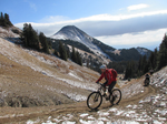
From the photo in the article, it appears to be the link between bear island and the spur 4 road, the eastern side of the Seymour river (Nice gravel track grinder), extension of Fishermans trail. Its a connector across to the old growth trail/seymour valley trailway. It's not a MTB trail anything like seymour or fromme, but if you've been blasting up the easy gravel road, suddenly have to slow down to get down to bear island can catch some people out. There's a nice lake along the ride about 200m off to the east as well to stop off at. Its got some pretty views and I've taken a few non MTB folk out there to get a sense of the vastness of the wilderness that surrounds us.
Does the LSCR actually have legit mtb trails (aside from the few main ones like Richard Juryn and Circuit 8)? I sometimes go up there to walk around rice lake or road bike to the damn, etc. and I always see people with mountain bikes in the parking lot but was always confused as to where they were going.
Posted by: PaulB
Right here:
Ah, yeah...I know that section! Definitely a corner out of character with the previous several kms of service road...
Having said that, the change in nature of the trail is pretty obvious to anyone paying the slightest bit of attention so I wouldn't point the finger of blame at the trail designer/builders...
Posted by: Bull_Dozer
Does the LSCR actually have legit mtb trails (aside from the few main ones like Richard Juryn and Circuit 8)? I sometimes go up there to walk around rice lake or road bike to the damn, etc. and I always see people with mountain bikes in the parking lot but was always confused as to where they were going.
Probably most are newbs/families going to Circuit 8 or up Spur 4 service road to the dam. Plenty of gravel bikes along Spur 4 as well though they aren't likely to access with a car.
Would be a good place for a tame overnight bike-packing trip!
For the record, the injured party's daugher posted in the NSR facebook feed ...
"this was my dad....so grateful he was found.....he just didn't come home and my mom wasn't home when he had headed out. He has done this trail a million times."
Just to end speculation that this was some newb that was in over his head.
Posted by: SixZeroSixOne
Where, exactly, is this trail?
Never heard of something referred to as "Seymour Falls Dam" and when I Google it, it points me to a lake in the middle of the Seymour ski area below Mystery Peak Chair!
Seymour Falls is where they built the dam. The falls no longer exist.
What was a little confusing about that injured biker report is that it stated the location as northeast of the dam. That would be in the restricted area of the watershed.
Seymour Falls had one of the highest annual precipitations of any location in Canada - about 4 meters a year.
Forum jump: