Vancouver Island Feb. Camping Help Please
There are some great logging road campsites up near port renfrew…I don't know what you are talking about go-t.
It's actually not a bad time of year to camp! The great thing about being on the coast is that there's awesome camping all year.
Sombrio is a great suggestion and really not that crowded…the beach is LONG and you can camp anywhere. Bear is a great option but you need to have backpacks. The trail is about 12km unless you find the side trail that comes down from the highway which is a much easier/shorter hike. Anywhere along the Juan de Fuca trail is a great idea, but as said, don't leave anything in your vehicle. It's just over an hour drive from Victoria. There's Mystic Beach if you're not prepared to hike to Bear; it's still wilderness-y but only just over 2km (you actually hike through it to get to Bear). If you don't have proper backpacks and stuff it's still doable, it's nice and quick and quite beautiful. The storms really brought a lot of deadheads up onto the beach this year though so there are fewer camping spots. There's a waterfall, a couple of creeks, and at low tide some awesome stuff to explore.
If you guys have backpacking gear you could do the whole Juan de Fuca trail, it's pretty awesome.
From Parkinson Creek to Payzant Creek is only 3km but a bit tougher of a hike, and while Payzant Ck is not on the ocean, it's a beautiful forested campsite. You can also hike in there from Botanical Beach (which is awesome at low tide), it's 8km I think and a VERY easy hike from that end.
If you park at Sombrio, little Kuitsche Creek isn't a far hike and there's likely to be no one there. It's also a forested campsite.
I think the car camping sites like French Beach and China Beach are closed right now but you can just park and walk into them, I've done that before.
If you want to head a bit farther up Island, Englishman River is a great car camping spot, the waterfall is really beautiful.
Out behind Port Renfrew there are tons of logging roads and amazing places to camp, plus lots of old trees and stuff.
Also you could go to one of the many places around Lake Cowichan, they're mostly run by logging companies. Or drive out to Carmanah-Walbran prov park-beautiful!
Lots of options for you. :)
camp at JR and fight the loc surf posse brah
Why slag free swag?:rolleyes:
ummm, as your doctor i recommend against riding with a scaphoid fracture.
san jo bay http://www.flickr.com/photos/uesser/798391015/
or if you like water taxies, flores island is hella cool, bout a 2 and a half hour hike to cow bay after the 30 minute boat ride to ahousaht, really cool hike too

This is great, thanks everyone for the info. The more I research, the more I feel I'd rather spend more time exploring the island and less time in Vicortia visiting people. I'm liking the idea of landing in Nanaimo and heading across the 4A to Long Beach area. I'd then like to meander down the west side to Pacific Rim Park, Port Renfrew, Juan de Fuca park to Victoria. Is this even possible though? Or after Ucluelet is it necessary to head inland to Port Alberni then back towards the coast? The big inlet heading to Alberni seems to be a bit of a block. Are there smaller ferries to bridge water in some locations? That and I'm not sure what kind of roads are cut through these areas. I'm trying to get a feel for the whole land with Google's Map and Terrain, which is sketchy, but I need you guys to set me straight. I'm getting really pumped for this trip, as I've only spent extended time in Victoria, Duncan, and Nanaimo, so I don't want to spend too much time driving down dead-end roads. Let me know if I'm being a complete noob here. I'm also on board with just exploring the Juan de Fuca trail for a bunch of days if that's a safe way to go. Thanks everyone.

west coast trail is not open.. and even if you do get on.. the nitnat narrows ferrry wont be there so.. youd be stuck. which is a shame cause just after is one of the best beaches ive ever been too.
unless you are talking bout driving in which case you cant drive down from tofino to renfrew.. youd have to go back to alberni head to bamfield and navigate a maze of active and deactivated logging roads.. not something id recomend. (not even that scenic anyways)
best way is go to tuf for a few days enjoy the rain there.. then head back the way you came down to vic, head out to renfrew the sooke way and enjoy the rain here. (doing what has been suggested juan defuca trail ,sombrio beach etc.)
.
Ha Ha! Made you look.
Yeah. Just to confirm. There is no road or ferry between ucluelet and bamfield and no road between bamfield and port renfrew.
Play : Comox Valley Mountain Biking - www.cvmtb.com
HAHAHAHAHAHAHAHAHA!
….
=/
Joke fail? Am I the only person shocked that most logging roads are gated and locked on the island?
Joke fail? Am I the only person shocked that most logging roads are gated and locked on the island?
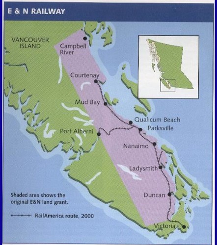
Where on Vancouver Island have you travelled. While the logging roads on the east side of Vancouver Island south of Campbell River are mostly locked, please educate yourself on two things.
E[HTML_REMOVED]N land grant and privately owned timberlands on Vancouver island and the ongoing problems of damage, theft, fires etc that happen on ungated and gated roads.
North and west halves of Vancouver island and many parts of the island along with many many forest recreation sites are easily accessible (snow level permitting) offering a huge area to explore.
So yes, sorry, the joke fell flat
Play : Comox Valley Mountain Biking - www.cvmtb.com
Boy I'll say… I guess bumping into gates where ever I wanted to go (Benson and surrounding mountains) really just bummed me on exploring much further. Normally being an Albertan, a gate across a logging road is completely foreign to me.
Boy I'll say… I guess bumping into gates where ever I wanted to go (Benson and surrounding mountains) really just bummed me on exploring much further. Normally being an Albertan, a gate across a logging road is completely foreign to me.
E[HTML_REMOVED]N Land Grant
anything on purple - mostly private land - gates likely
anything on green - mostly crown land - pretty much open to explore
Play : Comox Valley Mountain Biking - www.cvmtb.com
Thanks Adam and skifreak, that's what I was expecting.
E[HTML_REMOVED]N Land Grant
anything on purple - best MTB shuttle trails - gates likely
anything on green - mostly crown land - pretty much open to explore
FYP
Forum jump: