New posts

North Shore loop - leisurely 10560 ft climb over 27.5 miles

Aug. 2, 2011, 11:24 p.m.
Posts: 7707
Joined: Sept. 11, 2003

Old school North Shore XC ride from a couple of Saturdays ago:

Length: 27.5 miles (44.3 km)
Duration: 7 hours, 29 minutes, 29 seconds
Vertical elevation: 10560 ft (3218 m)
Average Speed: 3.7 mph

That's about a 7.3% average grade … or roughly 2 Alpe d'Huez climbs back-to-back.

On a 2001 Cove Stiffee FR hardtail with 3" of travel. From the GPS:

Altitude Profile:

Aug. 2, 2011, 11:30 p.m.
Posts: 11680
Joined: Aug. 11, 2003

Nothing is more awesome than finishing an epic, then seeing that epic little squiggle on a map :) Good ride :)

I did one a couple of years ago that I still want to finish:

Aug. 2, 2011, 11:43 p.m.
Posts: 4295
Joined: June 24, 2010

Good work! I wish I had a map like that for our 75 km, 2300 m East Van-Burnaby-Seymour-Fromme-East Van last year. GPS wasn't doing its thing appropriately, apparently. No idea how we got the numbers.

flickr

Aug. 3, 2011, 11:32 a.m.
Posts: 5635
Joined: Oct. 28, 2008

Those rides would kill a lesser man. Like me, for example.
:damn:

Wrong. Always.

Aug. 3, 2011, 11:48 a.m.
Posts: 8935
Joined: Dec. 23, 2005

Sorry I don't want to sound like a dick but you didn't climb 2 Aple d'Huez's back to back.

The classic Alpe d'Huez climb is 13km with 1130m of elevation gain at an average of 8%.

Pretty sure the stats put out by your gps are total vertical up and down. In order to break 10,000 ft of climbing on the shore you would need to climb from sea level to the top of the tram on Grouse 3 times. A single Alp d'Huez climb would be from sea level to just below the peak of Grouse.

Aug. 3, 2011, 12:19 p.m.
Posts: 7543
Joined: June 17, 2003

If I can ever get my crap together, I need to do a double crown on the 'cross bike.

Up Seymour and down, over to Lynn Valley via LSCR/Rice Lake, up to the tram station on Grouse and back, and back to Deep Cove.

"The song of a bird…We used to ask Ennesson to do bird calls. He could do them. How he could do them, and when he perished, along with him went all those birds…"-Return from the Stars, Stanislaw Lem

"We just walk around, and sometimes we go out and dance, and then we listen to the environment."-Ralf Hutter, Kraftwerk

Aug. 3, 2011, 3:19 p.m.
Posts: 7707
Joined: Sept. 11, 2003

Sorry I don't want to sound like a dick but you didn't climb 2 Aple d'Huez's back to back.

The classic Alpe d'Huez climb is 13km with 1130m of elevation gain at an average of 8%.

I have Alpe d'Huez 1150 m 15.2 km with 7.6% grade …

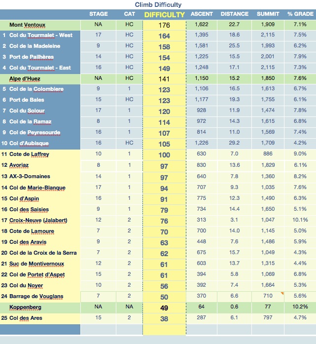
I also see online 14.5 km/1150 m

http://cyclinginfo.co.uk/blog/procycling/alpe-dhuez-climb/

and 13.2 km/1071 m

http://www.climbbybike.com/climb.asp?qryMountainID=5

So I guess it depends on where exactly you choose the start and finish. Similarly the maximum gradients reported range from 10.2% to 12% depending on where you look.

I agree you have a point that it is not exactly 2XAlpe … but in my defence I'll say the Schelcks didn't have a bone-rattling hardtail descent down 7th Secret after their climb.

Pretty sure the stats put out by your gps are total vertical up and down. In order to break 10,000 ft of climbing on the shore you would need to climb from sea level to the top of the tram on Grouse 3 times. A single Alp d'Huez climb would be from sea level to just below the peak of Grouse.

I'll bet if you walked/cycled from sea-level to the top of Grouse, depending on route, your accumulated elevation change could be well over 4000 ft, with a lot of up-and-down accumulated at the lower elevations.

The GPS stats are for up … the down was also recorded and was about 1.5 m off the up for the whole trip. I uploaded .gpx file to a website that did the plotting/profile/overlay and it reproduced the numbers.

I've calibrated this GPS with a Polar barometric altimeter (considered more accurate and higher resolution) on road rides (so a different situation again - to Whistler and back) and the numbers agree within about 5%. As to the tiny little ups and downs - yes I do wonder how accurate the GPS is with those, but if it is an artifact, it would (?) be a random error where uphills and downhills are exaggerated randomly up or down, due to the GPS cutoff resolution and number of triangulated satellites while on the move. However the data for the loop shows that all uphills and downhills add up exactly over the entire ride. I should check and see if I can apply a smoothing to the curve to more closely reflect altitude resolution.

The amount of paved road ridden was very small - probably about 2.5 km, virtually all of it between the Lynn Creek to Mountain Hwy. Believe me - there is a lot of climbing and descending in all those "flat" parts (eg Bridle Trail - probably of the order of 1000 feet gained and lost traversing there and back with no net elevation change). I've also measured the the amount of climbing on the 7th Secret "descent" with the Polar barometric altimeter, and the "descent" involved a fair amount of uphill, I believe it was in the order of around 1,000 feet.

Aug. 3, 2011, 3:24 p.m.
Posts: 11680
Joined: Aug. 11, 2003

Sorry I don't want to sound like a dick but you didn't climb 2 Aple d'Huez's back to back.

The classic Alpe d'Huez climb is 13km with 1130m of elevation gain at an average of 8%.

Pretty sure the stats put out by your gps are total vertical up and down. In order to break 10,000 ft of climbing on the shore you would need to climb from sea level to the top of the tram on Grouse 3 times. A single Alp d'Huez climb would be from sea level to just below the peak of Grouse.

A ride up an down a mountain that's 500m high will generally give a total elevation gain of more than 500m, since it will add up all the climbing. On Fromme, that's pretty much the same number, but on something like LSCR or Eagle, there is a lot of climbing on the downs and traverses, so it adds up to a lot more.

Aug. 3, 2011, 3:45 p.m.
Posts: 8935
Joined: Dec. 23, 2005

The GPS stats are for up …

If your stats are correct for the ups then I want to know what the real stats are for the Sea to Ski Triple Crown that MattJ and did back in 07.

I drew the route on Google Earth, then spit out the file to get the profile and route map. I've always stated the route to be about 10,500 ft of climbing based on the profile above.

When I saw your profile posted and quickly added up the big climbs I didn't get 10,500 ft thus my original post.

Aug. 3, 2011, 3:50 p.m.
Posts: 11680
Joined: Aug. 11, 2003

If your stats are correct for the ups then I want to know what the real stats are for the Sea to Ski Triple Crown that MattJ and did back in 07.

I drew the route on Google Earth, then spit out the file to get the profile and route map. I've always stated the route to be about 10,500 ft of climbing based on the profile above.

When I saw your profile posted and quickly added up the big climbs I didn't get 10,500 ft thus my original post.

The epic I posted was around 14k', I'd imagine that your ride would be similar.

Aug. 3, 2011, 8:06 p.m.
Posts: 1738
Joined: Aug. 6, 2009

Could you take a road bike on the section from Glenmore Drive to Cleveland Dam? Is it any worse than the gravel path from Lillooet Road to the bridge across Lynn Creek?

Ripping down Cap Road to Fullerton Ave. to cross the river is fun, but sometimes it'd be nice to get over to West Van without losing that much elevation.

Aug. 3, 2011, 8:22 p.m.
Posts: 10010
Joined: March 11, 2003

Old school North Shore XC ride from a couple of Saturdays ago:

Length: 27.5 miles (44.3 km)
Duration: 7 hours, 29 minutes, 29 seconds
Vertical elevation: 10560 ft (3218 m)
Average Speed: 3.7 mph

That's about a 7.3% average grade … or roughly 2 Alpe d'Huez climbs back-to-back.

On a 2001 Cove Stiffee FR hardtail with 3" of travel. From the GPS:

Altitude Profile:

yeah something's not right, you need to do some filtering there.

ie your graph is too jagged..

Is there a Vancouver in Taiwan?! I had no idea!!

Nothing sums up my life's achievements like my stuffed corpse, suplexing a cougar.

Aug. 3, 2011, 9:45 p.m.
Posts: 7543
Joined: June 17, 2003

Could you take a road bike on the section from Glenmore Drive to Cleveland Dam?

I'd like to know this as well. I've only walked part of that trail/path.

"The song of a bird…We used to ask Ennesson to do bird calls. He could do them. How he could do them, and when he perished, along with him went all those birds…"-Return from the Stars, Stanislaw Lem

"We just walk around, and sometimes we go out and dance, and then we listen to the environment."-Ralf Hutter, Kraftwerk

Aug. 3, 2011, 10:57 p.m.
Posts: 1
Joined: Nov. 21, 2002

sure it's not that long. short climb after the bridge then 50 yds or so of singletrack. I do it on my cross bike all the time

"We've been attacked by the intelligent, educated segment of the culture"

Aug. 3, 2011, 11 p.m.
Posts: 8935
Joined: Dec. 23, 2005

Brian beat me but you could easily take a road bike in from Glenmore to Cleveland dam.

Forum jump: