The Relics of Shaketown – Part I

A crosscut saw lies in a creekbed.
“There were snow-capped and forested slopes of mountains, the rivers in which hundreds of salmon cavorted, trees of astounding height and girth, waterfalls and the pools below were alive with leaping salmon, deep rock canyons that beckoned – the venturesome, skidroads, and the main Tote-road, V shaped flumes whose running waters floated shinglebolts down to Moodyville area.” – John Linn, 1871
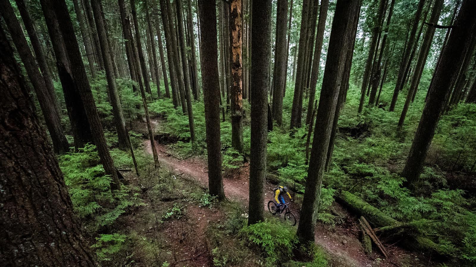
I roll to a stop where a shaft of sunshine pierces and otherwise shady forest. The freshly cut stumps on the hillside below steam as if they’re exhaling their last breaths and, far below, miniature machines toil ceaselessly in the black of the coal depot. The expansion of the port has been contentious in the suburb of North Vancouver where residential and industrial lands coexist tenuously. Although I hate to see trees and eagles replaced with more concrete and noise, I also know that without the financial sustenance of industry like this, North Vancouver wouldn’t be what it is today.

The old milltown of Moodyville still churns.
The area below me was the rough and raucous mill town of Moodyville in the late 1800’s. The mills capitalized on the tremendous bounty of timber in the ancient coastal forests around the Burrard Inlet. Fir was the wood of choice, with cedar taken mostly for making shingles. The Moodyville mill opened in 1863, originally under the Pioneer name, and it kick-started the slow transformation from wilds to civilization. Many of the routes chosen for flumes, skid roads, and rail lines are still in use today as our main thoroughfares.

Moodyville hotel.

Moodyville mill.

Upper skidder map…

Lower skidder map…
I kick my pedals and continue my ride, freewheeling down the 3rd street hill and turning north to follow a dirt trail up the east side of Lynn Creek. It was just about here that the Linn family, one of the first settlers in the area, built their simple homestead in the early 1860’s. The creek has had a few names over the years; Kwalcha, Fred, Linn, and finally Lynn Creek. Back then it teemed with Coho, Chinook, and Steelhead; nowadays it’s Labrador, Retriever, Shepherd etc…

The Linn homestead.

Twin Falls at Lynn Canyon.
Another 10 minutes of spinning up along the creek brings me into the quiet of the forest where I hear just the colorful bird calls above the low mechanical whir of my drivetrain. The flats above the canyon hold a small maze of trails and I zigzag over familiar terrain, noting small changes, some displaced moss or maybe a rock that’s rolled downhill. Minutia in the grand scheme of things. I roll along the rim, with the subtle roar of whitewater below, until I come to a faint linear clearing in the forest that’s worth a quick nod. It’s a remnant of the old Lillooet Trail.

Anyone remember the Coach House? There’s another piece of history.

Same area today.
From 1871 to 1877 the Province of British Columbia carved the Lillooet Trail into the land to bring cattle from the grasslands of Lillooet to the growing markets of Vancouver. To the great dismay of all involved, the first cattle drives were disastrous with roughly half the herds perishing en route. As a result the old Lillooet Trail was abandoned by the early 1890’s. A few sections have been incorporated into our modern day trail network but most of it sits forgotten with the moss and trees growing in little by little each year.

Looks a bit like Fisherman’s – roughly the same area.

It’s tough to see in a photo, but this is the trail today.
Crossing over to the east side of Lillooet Road, I drop into my granny and crank up a short technical section of singletrack that tapers into a nice easy gravel climb to a small peak. From the outlook at the top, I survey out toward Seymour and I recall an old goonies tale about the area. As I take a long slow drink of water and push my saddle down for the descent, the details start coming back to me. It goes something like this:
In the 1870’s and 80’s there was a fair amount of mining on the North Shore, mostly small independent operations and none of them very successful. One such operation, just a boy and an old man, found a vein quartz on northwest facing rock face just off the Lillooet Trail and they began digging for gold. They kept their claim secret, hiding the entrance and exit (old habits die hard in North Van eh?). Eventually the boy gave up and deserted the claim but the old man continued digging for years until the cave reached a depth of approximately 100 feet. The old man had gold fever and yet never cashed in a single nugget, and so the mine became known as Madman’s Cave by the time the old man passed. But it’s unclear – did he actually find the motherlode and squirrel it all away?

Diamond Vale Coal and Iron.

North Shore industry at the turn of the century.

Is it still out there?
My bounty is the downhill trail in front of me so I pedal off through the mud and the muck, picking amongst the multiple braids that twist all around me. I liked this area a lot more before they officially renamed the trails and brought in crushed gravel and starting hosting races. But hey, renaming, paving, changing, and bringing a lot more people to the area isn’t exactly a new tune for these parts so I take it in stride and find cheery little lips to pop off and corner puddles to roost. After an exciting few minutes, I’m back on Lillooet Road, spinning up toward Lynn Valley.

100 years and still standing – typical skidder remains.

Lantern turned relic.

Skid roads in use.

Three horsepower.
The Circuit 8 trails are worthy of a quick XC blast, thanks to the top notch work that’s been done in recent years, so I loop through there and hold on tight for the descent to Fisherman’s Trail along the Seymour River. If you’ve ever pedaled Fisherman’s and wondered about the 2 wooden archways on the side of the trail, they are doorways from a grand log house that was occupied by Greater Vancouver Water District employees in the early 1900’s. In fact, this wide spot in the valley held a small community until the Seymour watershed was closed in 1941 to safeguard the water supply, and the buildings were removed. It wasn’t until 1989 that the valley was reopened to the public.

Scott’s Ranch.

Scott’s Ranch.
The Homestead Trail brings me, somewhat painfully, back up the hill to the Rice Lake area. The lake has seen plenty of change over the years with notable points being when it served as a watering hole for ranch land around it, and the two times it was drained completely.

Rice Lake, 1927.

Rice Lake shingle bolt hauling, 1907.

Skating on Rice Lake, 1911. It’s probably been decades since it last froze.
I continue on my way and after just a few minutes of breezy pedaling I’m parking my bike outside the End of the Line cafe at the terminus of Lynn Valley Road. Hendrickson’s General Store originally occupied this spot in the early 1900’s, serving as Lynn Valley’s first post office and as the depot for the trolley line. I grab a coffee, saunter across the street, and walk my bike down a gravel trail back into the sultry lushness of Lynn Canyon.

End of the Line, early 1900s.

Streetcar in Lynn Valley.
The canyon has always been set aside as a place for recreation. Even in the slash-and-burn pioneer days of land clearing our forefathers had the foresight to preserve this exceptionally beautiful spot, mainly for cool summer reprieves. I plunk myself down on a little rocky bluff overlooking an azure pool, breathing deeply the cold fresh air washing down the narrow canyon. Even on a busy summer day, you can always find a gem of a spot in the canyon, serene and secluded. Just downstream from this spot was the old bandstand and playground, washed out by a huge landslide in 1919. The deciduous trees and general jumble of the creek are evidence of this slide and, in the 1970’s, rusting pieces of the playground equipment still protruded from the creek.

Lynn Canyon Bandstand, 1912.

Lynn Canyon suspension bridge, 1910.
Farther up the creek, in the headwaters, there many more artifacts of the logging and mining days, some in tidy piles on the side of the trails, others out in forest right where they came to a stop. You can’t pedal a bike up there but a day spent wandering the forests out that way is a day well spent. On one such occasion, far off in the bush, I came across a barely recognizable ore card and I studied it for quite a while, wondering if anyone else knows it’s there. Thinking about it now as I sip my coffee, my mind drifts to the creeks and valleys and ridges out that way that I’ve yet to explore.

A Cedar’s Mill truck, 1920.

A Cedar’s Mill truck today.

Old Greater Vancouver Water District pipelines.
Enough daydreaming, it’s time to roll again and see what other old trails and tales I can dig up…
Does your mind wander to the historic?


Comments
Susan
9 years, 9 months ago
Beautifully done. Thank you. S.
Reply
NV73
10 years, 9 months ago
Nicely done. Thanks for this!
Reply
Jerry-Rig
10 years, 9 months ago
Great article Bryce!
Reply
Dirk
10 years, 9 months ago
What a fantastic (yet depressing) article.
Since we're not really talking "secret trails" here…it would be pretty cool if somebody put together a map of this route with waypoints and landmarks, no?
Reply
Heathen
10 years, 9 months ago
That would be cool, looks like a cool ride for my parents.
Reply
Bryce
10 years, 9 months ago
I can do that. It'll have to be an image though rather a gps file cuz I suck at gps stuff.
I'll post it with Part 2.
Reply
Daniel Louie
10 years, 9 months ago
how do you add an article to favorites?
Reply
Paul Snyder
10 years, 9 months ago
Favourite on my browser. Then I can easily find the link to refer back to the article anytime I want.
Reply
CraigH
10 years, 9 months ago
Thanks for writing up the article, great read.
I need to learn more about the North Shore history.
Most of my BC history knowledge from this era is from exploring the KVR and other smaller rail lines across BC & northern Washington state.
Reply
Oldfart
10 years, 9 months ago
Well done. I have a couple books on the early days of North Van. One about logging in the Capilano Valley before it was dammed. The Bowser Trail and Cap Pacific trails are the old rail line that carried logs from the valley down to the foot of Pemberton Ave. If you go to the end of Rabbit Lane in West Van and follow the gravel road until you can't go further, off to the right is the remains of the railway trestle.
Lynn Valley, The Early Days was written by The Scribe, Draycott. That bronze sculpture at Lynn and Mountain Highway is him and the street is named in his honour.
Reply
Tonestar
10 years, 9 months ago
Ahhhhh, the "Roach House", what memories.
Nice article Bryce, I love the history of the North Shore area.
Funny, when I was in high school, the family of a girl in my class owned the "End of the Line Cafe", it was just another corner store back then, but cool history.
Reply
Paul Snyder
10 years, 9 months ago
This is sweet reading, Bryce! Thank you. Adding this straight to my favourites! 🙂
Reply
Please log in to leave a comment.